| COUNTRY FACTS: MAURITIUS | |
|---|---|
| Name(official): | Republic of Mauritius |
| Name(short): | Mauritius |
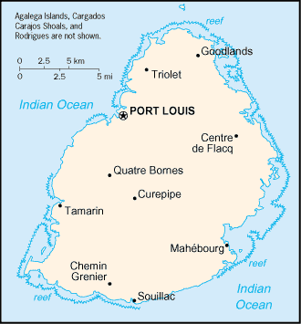
| Capital City: | Port Louis |
| Location: | Southern Africa, island in the Indian ocean, east of madagascar. |
| Coordinate: | 20 17 S, 57 33 E |
| Independence: | (From Britain) March 12th, 1968. |
| President: | Sir Anerood JUGNAUTH (President) Navinchandra RAMGOOLAM (Prime Minister) |
| Type of Government: | Parliamentary democracy |
| Total Area: | 2 040sq.km. |
| Population: | 1 240 827 (July 2006 est.) |
| People: | Indo-Mauritian 68%, Creole 27%, Sino-Mauritian 3%, Franco-Mauritian 2% |
| Religion: | Hindu 48%, Roman Catholic 23.6%, other Christian 8.6%, Muslim 16.6%, other 2.5%, unspecified 0.3%, none 0.4% (2000 census) |
| Languages: | Creole 80.5%, Bhojpuri 12.1%, French 3.4%, English (official; spoken by less than 1% of the population), other 3.7%, unspecified 0.3% (2000 census) |
| Literacy: | 85.6%total, 88.6%male, 82.7%female (2003 est.) |
| Currency: | Mauritian rupee (MUR) |
| GDP(per capita): | $12 800 (2005 est.) |
| Arable Land: | 49.02% (2005 est.) |
| Agriculture: | Sugarcane, tea, corn, potatoes, bananas, pulses, cattle, goats, fish. |
| Natural resources: | Arable land, fish. |
| Embassy in Japan: |
|
| General Info: | General information on Mauritius |
| International Phone Code: | +230 |
ECONOMY: BUSINESS, TRADE AND INVESTMENT
- Tourism: Some of the main tourist attractions are ...
- Casela Park
- Black river Gorges
- Ile aux Cerfs (the most beautiful beach in Mauritius)
- Pereybere beach L’Aventure du sucre
- Grand Bay
- Martello Towers
- The Troilet Shivala
MAJOR CITIES
Port Louis, Grand Bay, Beau Bassin, Belle Rose, Curepipe, Mahebourg, Triolet, Quatre Bornes.
NEWS
INTERNATIONAL ORGANIZATIONS:
- United Nations
- African Union
- COMESA
- SADC
- NEPAD
GOVERNMENT: ADMINISTRATIVE UNITS
9 districts and 3 dependencies*; Agalega Islands*, Black River, Cargados Carajos Shoals*, Flacq, Grand Port, Moka, Pamplemousses, Plaines Wilhems, Port Louis, Riviere du Rempart, Rodrigues*, Savanne.