| COUNTRY FACTS: CONGO | |
|---|---|
| Name(official): | Republic of the Congo |
| Name(short): | Congo(Brazzaville) |
| Capital City: | Brazzaville |
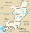
| Location: | West Central Africa, bordering the south atlantic between Angola and Gabon. Click to enlarge
 Map of Congo, Republic of |
| Coordinate: | 1 00 S, 15 00E |
| Independence: | (From France) August 15th; 1960. |
| President: | Denis SASSOU-NGUESSO |
| Type of Government: | Republic |
| Total Area: | 342 00sq.km. |
| Population: | 3 702 314 |
| People: | Kongo 48%, Sangha 20%, Teke 17%, M'Bochi 12%, Europeans and others 3%. |
| Religion: | Christians 59%, animist 48%, muslims 2%. |
| Languages: | French(official), Lingala and Monokutuba(lingua franca trade language), many local languages and dialects (of which Kikongo is the most wide spread). |
| Literacy: | 83.8%total, 86.6%male, 78.4%female (2003 est.) |
| Currency: | Communaute Financiere Africaine Franc (1CFAF =100centimes) |
| GDP(per capita): | $1 300 (2005 est.) |
| Arable Land: | 1.45% (2005 est.) |
| Agriculture: | cassava(tapioca), sugarcane, rice, corn, vegetable, peanuts, coffee, cocoa, forest products. |
| Natural resources: | Petroleum, timber, potash, lead, zinc, uranium, copper, phosphate, gold, magnesium, natural gas, hydropower. |
| Embassy in Japan: |
|
| General Info: | |
| International Phone Code: | +242 |
ECONOMY: BUSINESS, TRADE AND INVESTMENT
- Tourism:
MAJOR CITIES
Brazzaville, Ponte-Noire, Loubomo, Nkayi
NEWS
INTERNATIONAL ORGANIZATIONS:
- United Nations
- African Union
- ECCAS
- NEPAD
GOVERNMENT: ADMINISTRATIVE UNITS
10 regions (regions, singular - region) and 1 commune*; Bouenza, Brazzaville*, Cuvette, Cuvette-Ouest, Kouilou, Lekoumou, Likouala, Niari, Plateaux, Pool, Sangha.


