| COUNTRY FACTS: NAMIBIA | |
|---|---|
| Name(official): | Republic of Namibia |
| Name(short): | Namibia |
| Capital City: | Windhoek |
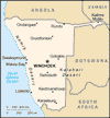
| Location: | Southern Africa, bordering the South Atlantic Ocean, between Angola and South Africa. Click to enlarge
 Map of Namibia |
| Coordinate: | 22 00 S, 17 00 E |
| Independence: | (From South African mandate) March 21st; 1990 |
| President: | Hifikepunye POHAMBA (President), Nahas ANGULA (Prime Minister) |
| Type of Government: | Republic |
| Total Area: | 825 418sq.km. |
| Population: | 2 004 147 |
| People: | Black 87.5%, white 6%, mixed 6.5% Note: about 50% of the population belong to the Ovambo tribe and 9% to the Kavangos tribe; other ethnic groups includes Herero 7%, Damara 7%, Nama 5%, Caprivian 4%, Bushmen 3%, Baster 2%, Tswana 0.5%. |
| Religion: | Christian 80% to 90% (Lutheran 50% at least), indigenous beliefs 10% to 20%. |
| Languages: | English 7% (official), Afrikaans common language of most of the population and about 60% of the white population, German 32%, indigenous languages (Oshivambo, Herero, Nama). |
| Literacy: | 84%total, 84.4%male, 83.7%female (2003 est.) |
| Currency: | Namibian dollar (NAD), South AFrica rand (ZAR) |
| GDP(per capita): | $8 200 (2005 est.) |
| Arable Land: | 0.99% (2005) |
| Agriculture: | Millets, sorghum, peanuts, grapes, livestock, fish. |
| Natural resources: | diamonds, copper, uranium, gold, lead, tin, lithium, cadmium, zinc, salt, hydropower, fish. Note: suspected deposits of oil, coal, and iron ore |
| Embassy in Japan: |
|
| General Info: | |
| International Phone Code: | 264 |
ECONOMY: BUSINESS, TRADE AND INVESTMENT
- Ministry of Mines and Energy
- Ministry of Trade and Industry
- Tourism: Main tourist attractions includes ....
- Ais-Ais & Fish Canyon
- Namib-Naukluft National Park
- Etosha National Park
- Waterberg National Park
- Kaudom National Park
- Namibia Board of Tourism
- Ministry of Environment and Tourism
MAJOR CITIES
Windhoek, Walvis Bay, Grobabis, Grootfontein, Karasburg, Katima Mulilo, Luderitz, Swakopmund
NEWS
INTERNATIONAL ORGANIZATIONS:
GOVERNMENT: ADMINISTRATIVE UNITS
13 regions; Caprivi, Erongo, Hardap, Karas, Khomas, Kunene, Ohangwena, Okavango, Omaheke, Omusati, Oshana, Oshikoto, Otjozondjupa.


